Saturday, October 31, 2015

Greenpoint Shul - Congregation Ahavas Israel

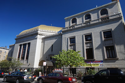
Temple Beth-El & Congregation Ahavas Israel Buildings
Greenpoint Shul - Congregation Ahavas Israel
Neighborhood: Greenpoint
Adress: 108 & 110 Noble Street

Shul History
The buildings occupied by the Ahavas Israel Jewish congregation in Greenpoint were once two separate Synagogues. The now defunct Temple Beth-El Synagogue was a reform congregation organized in 1886. They met in Germania Hall on Franklin Street prior to purchasing the structure on 108 Noble Street from the Church of the Reconciliation in 1887. The Church of the Reconciliation building was constructed ca. 1871.[1][2] Under the leadership of Rabbi M.J. Luebke their services were held in German and Hebrew. After the dismissal of Luebke in 1897, sermons were given in English.[1] Originally located in Keramos Hall on Manhattan Avenue, Congregation Ahavas Isreal partnered with the Congregation Shayrish Israel (Congregation of the Relic of Israel) and began construction on their new synagogue adjacent to the Temple Beth-El Israel in 1904.[1][2] As industries left Greenoint much of Temple Beth-El’s congregation went with them. With a shrinking congregation the Temple Beth-El disbanded.[3] Today, Ahavas Israel owns both buildings and is the last of five synagogues in Greenpoint.[1][3]
Stained glass windows of the two synagogues side by side
Temple Beth-El & Ahavas Israel Windows
Architecture
The building formerly occupied by Temple Beth-El has Gothic-Revival features on a townhouse like frame. Ahavas Israel had their building designed in the Romanesque Revival style. The difference in styles is most apparent in the fenestration of the two buildings. The Temple Beth-El building has lancet windows and an entrance with a pointed arch, typical features of its style. Ahawath Israel’s original house of worship features rounded Romanesque arches. It’s worth noting that the Beth-El building once had a square dome at the front of it.

Interior
Ahavas Israel’s original sanctuary is cream colored and surrounded by a wood-faced balcony. Overhead is a barrel vaulted ceiling with three skylights. Additional light is provided by a Victorian era chandelier with frosted glass.[3] Additional details regarding the building’s interior listed in the book “Sacred Havens of Brooklyn” are quoted below.
All eyes are drawn to the holy ark, guarded from above by golden lions of Judah that flank gilded tablets of the Ten Commandments. A wheel window above the ark is filled with the stained-glass Shield of David outlined in red against a turquoise sky. Colorful stenciling surrounds the window and ceiling, while a dark wood bema, the reading of the table for the Torah scrolls, has brass menorahs on each corner.
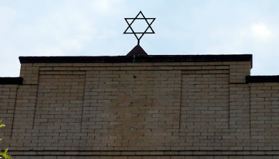
Star of David sitting on top of Ahavas Israel building's cornice

References:
  1. Brian Merlis & Riccardo Gomes Brooklyn's Historic Greenpoint Gomerl Publishing, NJ 2015
  2. "Our History" GreenpointShul.org
  3. Cook, Terri Sacred Havens of Brooklyn. Charleston South Carolina: The History Press, 2013
Thursday, October 22, 2015

Church of St. Luke and St. Matthew

Front of church
Church of St. Luke and St. Matthew
Decorative stone arch of the main entrance of church
Arch Over Main Entrance to Church
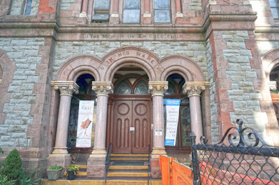
Chapel entrance featuring three stone arched openings in front of a decorative wood door
Chapel Entrance
Neighborhood: Clinton Hill
Adress: 520 Clinton Avenue

The Church
The Church of St. Luke and St. Matthew was not the first at this location. The original church located on this site was built in 1835 for the Trinity Church congregation. However, the congregation was unable to successfully grow and when it couldn’t meet its financial obligations, they lost the property in foreclosure. Their original square rubblestone structure was incorporated into the design of the existing church. The following church to utilize the site was St. Luke’s Protestant Episcopal Church, organized in 1841; the St Matthews congregation didn’t join the church until 1943. Additions to the original structure were added by the new church in 1853 and 1886. A fire destroyed much of the building in 1887. So in 1888-1891 St. Luke’s rebuilt the church resulting in the existing, grand ecclesiastical structure here today.[1] It was and still is the largest Episcopal Church in Brooklyn.[2]

Interior shot facing the apse from behind the pews showing the columns, pews and vaulted ceiling
Church of St. Luke and St. Matthew Interior
Rose window with stained glass
Rose Window
Lancet windows with Tiffany Stained Glass depicting the Magi's visit to baby Jesus
Tiffany Stained Glass Church Window
Showing Magi's Visit to the Infant Jesus
Image of ceiling over choir and apse showing stained glass windows of the apse and stained glass skylight
Ceiling Above Choir & Apse
Three images showing the organ, a typical hanging light and a gold colored decorative pulpit on a pedestal
Organ, Light & Pulpit
White reredo flanked by angels showing St. Peter, St. Paul and a crucifixion scene at rear of apse below the apse's stained glass windows
Church of St. Luke and St. Matthew Reredo
Architecture
Designed by John Welch, the church boasts a classically inspired façade modeled after the basilicas of Italy.[1][2] John Welch was a Brooklyn architect responsible for designing many churches. The AIA Guide to New York City refers to the church’s style as “Eclecticism gone berserk”.[3] Indeed, there are elements of several design motifs contained within the building; although, Romanesque Revival is the dominant architectural style. The façade features “greenish stone walls, Romanesque arches, and Ruskinian Gothic polychromy in three shades of brown”.[3]

The twenty eight foot diameter rose window over the entrance, one of the largest in Brooklyn, was donated by the children of the Sunday School in 1890.[1] Most of the windows in the nave were produced by Tiffany and installed in 1896-1897.[1][2] All but one of the sets of stained glass windows has a scriptural theme. Although, the north and south transepts were originally furnished with pews, they are now more open and house religious artifacts including an altar from the Church of St Michael on Adelphi Street. The pulpit was dedicated after the church was rebuilt in 1890. On opposite sides of the chancel is the organ, built by M. P. Mollar in 1916, and wood choir stalls.[1] The apse windows, alter and reredos are part of the 1853 construction.[2]

For a more detailed history of the church visit it during Open House New York. They participate in OHNY every year.

More Photos

References:
  1. “The Church of St. Luke and St. Matthew, A Guide to the Building” Church Brochure for OHNY
  2. Cook, Terri Sacred Havens of Brooklyn. Charleston South Carolina: The History Press, 2013
  3. White, Norval, Willensky, Elliot, and Leadon, Fran AIA Guide to New York. Oxford University Press, 2010

Saturday, October 17, 2015

Fort Tilden - Queens

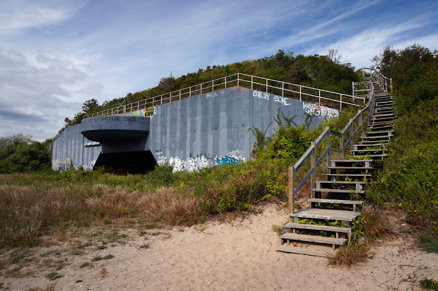
Photo of Battery Harris East showing steps to observation platform above in the foreground
Battery Harris East
I’m stepping out of Brooklyn for this post on Fort Tilden. Just across Jamaica Bay from Marine Park’s Dead Horse Bay is Fort Tilden, a popular spot for Brooklynites and Queens residents alike.

Intro
Located on the southwest end of the Rockaway Peninsula, Fort Tilden was an army base of 309 acres strategically located to defend New York Harbor. The base was built in 1917 as part of an emergency military buildup during WWI. The base began with smaller 12” gun batteries to defend against maritime threats but evolved over time to address new advances in military technology, as well as new types of warfare.[1] Although covered with dunes and vegetation today, most of the base was once  an open landscape.[2] In 1974 military operations ceased and the base was turned over to the National Park’s Service for incorporation into the Gateway National Recreation Area. After being decomissioned nature was allowed to return the base's landscape to the natural state it's in today.[1][2]


Large 16" anti-ship artillery gun on beach of Fort Tilden
Fort Tilden 16" Gun Emplacement
Looking down barrel of large 16" anti-ship artillery gun on beach of Fort Tilden
View of Crew and Rails for Munition Supply from Barrel of 16" Gun
(Photo Source: History of Fort Tilden at www.oocities.org)
Nike Hercules Missile pointed up on launching device at Fort Tilden
Nike Hercules Missile at Fort Tilden
(Photo Source: Techbastard.com)
Looking out from mouth of Battery Harris East bunker
Looking Out from Under Battery Harris East Bunker
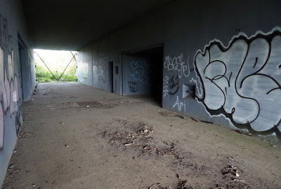
Looking into the interior corridor of Battery Harris East with entrances to rooms on either side of corridor
Looking Into the Battery Harris East Bunker
Machine gun pill box in the vegetated dune behind Fort Tilden Beach
Pill Box / Machine Gun Nest
Defenses and Fortifications
The fortifications and armament constructed during WWI were part of the Taft system of defense. Secretary of war William Taft outfitted U.S. defense fortifications with electric lights, motorized ammunition hoists, searchlights, telephone communications and observation posts for accurate targeting of enemy ships. After WWI anti-aircraft guns and camouflage were added to address the new threat from aerial attack. In the mid-1930s, prior to the Second World War, the depression era WPA constructed many additional buildings on the base. During WWII, larger, M1919MII 16" gun batteries were added and existing guns were fortified in concrete bunkers known as casemates, with additional protection and camouflage provided by a cover of sand and vegetation. From above the batteries are hidden within the dunes. In 1954-1955, during the Cold War, Fort Tilden’s defense capabilities were enhanced with additional anti-aircraft guns and Nike surface to air missiles.[3]  
Fort Tilden Building
Fort Tilden Magazine Building
Remaining Buildings
Since the base was decommissioned much of its infrastructure, including large gun mounts on the beach, has been covered by sand dunes and maritime vegetation. Many of the remaining buildings have been unmaintained, vandalized and damaged by storms including Hurricane Sandy. The most impressive remaining structures include 4 large artillery bunkers known as Battery Harris East and Battery Harris West. One of the bunkers has an observation platform with public access. In addition to the bunkers there are pill boxes (machine gun nests) in the dunes behind the shoreline, a hanger, magazine buildings (for ammunition storage) and a generator building among others.[5] 

The Park
If you visit Fort Tilden today, there are many types of park programs and facilities for you to take advantage of. The Rockaway Artist Alliance and the Rockaway Theatre Company offer cultural programming. “Tours and ranger-led programs highlight many great spots to see wildlife in the maritime forest”. The observation deck on top of one of the bunkers can be used for taking in panoramic views and bird watching.[4] For active recreation, the shoreline offers typical beach activities and there are athletic fields for soccer and baseball at the east end of the park.

Additional Photos

View of Rockaway and Gil Hodges Memorial Bridge from observation platform
View from Observation Platform on top of Battery Harris East

References:
  1. "A Detailed History of Fort Tilden" NationalParksService.gov
  2. Selvek, Christina & Auwaerter, John Cultural Landscape Report for Fort Tilden Olmstead Center for Landscape Preservation - National Park Service, Boston Massachusetts, 2005
  3. “Nike Missile Site NY-49 Fort Tilden New York” TechBastard.com
  4. “Fort Tilden” NewYorkHarborParks.com
  5. "The History of Fort Tilden" www.oocities.org

Tuesday, October 13, 2015

Historic First Church of God in Christ

Church as see from corner
Historic First Church of God in Christ
Facade of church
Historic First Church of God in Christ
West side of church
Historic First Church of God in Christ
Portico with entablature featuring Hebrew and English "Gates of Righteousness"
Historic First Church of God in Christ Portico
Neighborhood: Crown Heights
Address: 221 Kingston Avenue

The Church
The Historic First Church of God in Christ building was constructed in 1923 as a synagogue, known as Shaari Zedek, for a wealthy German Jewish population.[1] Purchasing the house of worship in 1969, the Historic First Church of God in Christ retained most of the building’s architectural heritage in spite of its ecclesiastic transformation.[1][2] The building is a Neo-Classical style structure with the facade resembling that of ancient Roman architecture. According to the book, The Lost Synagogues of Brooklyn, the interior has “well-preserved highlights and details that recall the interiors of opulent movie palaces”.[2] The reference to movie palaces eludes to the Art Deco and Arts and Crafts style of the interior.[1] According to Brownstoner further details include elaborate stenciling, decorative metal screens, painted motifs and stained glass.[1]

The Architects
The First Church of God in Christ building was Designed by S.B. Eisendrath and B. Horowitz architects. The pair of architects had also designed the Temple Beth Elohim in Park Slope and Tivoli Theatre in Manhattan.[1][3] In addition, Eisendrath was noted for having designed several important public buildings while being one of the youngest architects in Chicago at the time. By 1892 those buildings included churches, a school for nurses and a home for the aged.[4] 

References:
  1. Morris, Montrose "Walkabout: The Temples of Bed Stuy and Crown Heights" Brownstoner 11 February, 2010
  2. Levitt, Ellen The Lost Synagogues of Brooklyn Bergenfield NJ, 2009
  3. Building Age and National Builder Vol. 43 April, 1919
  4. Columbian Exposition Dedication Ceremonies Memorial Chicago: The Metropolitan Art Engraving and Publishing Company, 1892

Thursday, October 8, 2015

Red Hook Fairway Trolley

Trolley behind red brick former factory building turned grocery store
Red Hook Trolley
Looking at trolley from Fairway Grocery Store
Red Hook Trolley
Neighborhood: Red Hook
Address: 480 - 500 Van Brunt Street

The story of the Fairway Trolley in Red Hook is one of a dream unfulfilled. Transit buff Bob Diamond dreamt of reviving part of Red Hook’s trolley line. He and friend Gregory Costillo founded the Brooklyn Historic Railway Association (BHRA). Then, they purchased trolleys, equipment and parts with the plan of renewing trolley service from Red Hook to Atlantic Avenue and Downtown Brooklyn.[1][2] Diamond and the BHRA worked with the New York City DOT during the 1990s and early 2000s to make the dream a reality. The stable of 17 trolleys owned by the BHRA included a maintenance vehicle and fifteen PCC street cars from the 1930’s, as well as one antique trolley from Norway built in 1897.[1]


Trolley tracks embedded in esplanade paving on Red Hook Waterfront
Trolley Tracks Along Esplanade & Catenary Pole in Background
The Trolleys
The BHRA installed a one-mile loop of tracks beginning from the waterfront property of local developer and preservation supporter Greg O’Connell. BHRA tracks extended west from their warehouse along the esplanade before transitioning to city streets. The tracks ran along Conover, Reed and Van Brunt Streets.[3] Unfortunately, the BHRA never made it to their final destination in Downtown Brooklyn.

Constructed of wood, the antique Norwegian trolley was built by Schuckert & Co. in Nurnberg Germany.[1][3] The “streamlined PCC cars” were made in America and introduced to New York in 1936 as a final attempt to prevent the electric trolley’s elimination by the city. However, mayor LaGuardia was unsupportive of continued trolley service and the effort failed.[1] The city’s street cars were eventually phased out in favor of buses.

Bob Diamond
Former head of the BHRA, Bob Diamond is an electrical engineer who is also known for rediscovering the ca. 1844 Atlantic Avenue LIRR tunnel when he was an 18 year old.[1][3] During his time with the BHRA, he purchased and installed signals,  catenary poles, tracks and other equipment. In addition, he worked to secure grants, organized trolley related events and spent a lot of time advocating for renewed trolley service.[1] 


Old trolley route map for Brooklyn
Historic BMT Trolley Route Map
The Project
The neighborhood’s access to greater Brooklyn has been limited for a long time. Red Hook trolley service was replaced by municipal buses ca. 1950.[5] Later in the 1950s, the neighborhood was cut off from the rest of Brooklyn by Robert Moses’s BQE.[6] One of the BHRA’s goals was to bridge the transportation gap between Red Hook and neighboring communities. Ultimately, the City DOT determined that there were better ways to alleviate Red Hook’s transportation woes than by renewing trolley service. A DOT study determined that the neighborhood’s roads were too narrow and would require the elimination of on street parking in places to make room for the street car’s wide turns. In addition, the report stated that “trolleys pose a risk to cyclists”. “The study made a recommendation not to implement a streetcar system in this area due to cost, land-use considerations and impacts on the street network”.[6] In a Curbed article Bob Diamond claimed that Mayor Bloomberg killed the project on his second day in office.[7] Whether the study’s recommendations or the changing priorities of a new administration are to blame is unclear but city support for the trolley project ended in 2003, not long into Mayor Bloomberg’s tenure.[3] After municipal support for the trolley project was terminated, Mr. Diamond was required to find outside financial backing. Making things worse, there were disputes between him and other volunteers and he was evicted from the warehouse where the BHRA had operated rent free for more than ten years. In 2004, when Diamond could not secure funding from other sources in time, tracks that had been constructed in the city right-of-way were removed and the streets repaved. 

After the Project
Four trolleys remained in Red Hook for over a decade.[3] Three sat on tracks behind Fairway and were damaged from flooding caused by Hurricane Sandy. The corrosive salt water accelerated the trolley’s decay, raising fears that restoration would become too cost prohibitive.[7]  So, in 2014 they were transferred, albeit without Bob Diamond’s consent, along with a “significant donation” to the Branford Electric Railway Association to facilitate their acquisition by others for potential restoration. The organization operates the Shore Line Trolley Museum in East Haven CT.[8]  The last remaining trolley sat in a nearby warehouse until it was moved to the tracks behind Fairway where the other three trolleys once were and where it remains to this day.

References:
  1. Geberer, Raanan “Last Minute $50,000 Grant Gives Trolley Project New Life” Brooklyn Heights Press & Cobble Hill News 24 October, 2002
  2. Gallahue, Patrick “Red Hook trolly work set to roll in October” The Brooklyn Papers 10 September, 2001
  3. “Red Hook Trolleys Removed” Forgotten NY February 2014
  4. “A Desire Named Streetcar” New York Times 24 October, 1999
  5. Ryan, Joseph S. “Letter to the Editor: Complaints of Transit Problem in Red Hook” Brooklyn Daily Eagle 23, December 1951
  6. McLaughlin, Mike “Red Hook Trolley would be folly, city sez” Daily News. 20, April 2002
  7. Kensinger, Nathan “As Neighborhood Transforms, No Room For Red Hook Trolleys” Curbed 20 February 2014
  8. "The O'Connell Organization Donates Trolley Cars" RedHookWaterfront.com

Friday, October 2, 2015

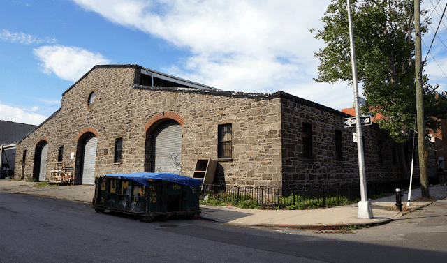
Brooklyn Clay Retort and Fire Brick Works Storehouse

Photo of building from corner
Brooklyn Clay Retort and Fire Brick Works Storehouse
Bull's eye window with current company's name in stained glass
Brooklyn Clay Retort and Firebrick Works Storehouse
Bull's Eye Window
Neighborhood: Red Hook
Address: 76 - 86 Van Dyke Street

Architecture
The building dates to the mid-nineteenth century, circa 1859, and was part of a complex established during the first wave of industrial development in Red Hook. The “powerful” looking structure was constructed from roughly cut, dark gray schist in an ashlar pattern with brick and sandstone trim.[1][2] The basilica-esque building form is typical of mid and late nineteenth-century low-rise industrial buildings. Today the building is supplemented with electrical lighting; however, its primary light source in the nineteenth century was a clear story of windows, skylights and a bull’s eye window in the Van Dyke Street facade.[1] The stained glass in the bull’s eye window beers the current occupant’s company name "Carvart Glass".


Historic illustration showing Brooklyn Clay Retort and Fire Brick Works complex
Illustration from Henry Stiles History of Brooklyn
(Image: Courtesy of MaggieBlanck.com)
Current bird's eye view of Brooklyn Clay Retort and Fire Brick Works complex
Bing Bird's Eye View of Brooklyn Clay Retort and Fire Brick Works Complex
In the historic lithograph above you can see the Brooklyn Clay Retort and Fire Brick Works Storehouse on the left. The building on the right with the tall smokestack was built by the company to house a steam engine and boiler rooms, as well as a carpentry shop for fabricating patterns and molds required for the various shapes of fire brick.[1] Although heavily modified, remnants of this structure still remain. Note: in the historic image, the relationship of the buildings to the water is not accurate.

Plaque commemorating the Landmark designation of the building
Landmark Plaque
The plaque pictured above commemorates the Brooklyn Clay Retort and Fire Brick Works Storehouse's Landmarks designation. The Storehouse was the first building to achieve landmark status in Red Hook. Prior to being landmarked, the building was purchased and restored by Greg O'Connell, a local developer.[3]


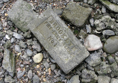
Fire brick discovered on shoreline of Manhasset Bay, NY
Cropped Photo of Company's Fire Brick
As Seen on Southern Manhasset Bay, NY Shoreline April 18, 2009
(Image: Courtesy of Sandy Richard)
The Company
The building was the storehouse for the J.K. Brick & Company, later the Brooklyn Clay Retort and Fire Brick Works.[1] The J.K. Brick & Company was started in 1854 to manufacture products used in the production of illuminating gas by companies such as the Brooklyn Gas Light Company. Constructed near Red Hook's Erie Basin, Clay was once shipped from South Amboy, NJ to the Firebrick Works where it was made into “firebrick”.[2] Fire bricks are used to line kilns and furnaces. In addition to fire bricks, the company sold clay retorts, fire clay and stove lining bricks, as well as fire sand and fire cement for laying brick.[1][4][5] One of the innovations developed by the company’s founder was the fire clay retort, a vessel used in the process of coal gasification. The J.K. Brick & Company is credited with being the first business in the country to produce fire clay retorts. The company remained profitable into the late 1800s but sometime in the early 20th century closed its doors for good.[1][5] In my research it was unclear when the company ceased its operations but according to the Landmarks Preservation Commission report, the American Molasses Company began using the Brick Works buildings in the 1930s. Although the New York - New Jersey area was once a major fire brick manufacturing center, the Brooklyn Clay Retort and Fire Brick Works buildings are the last known remaining structures in the area.[1]

Company's Founder
The company’s founder, aptly named Joseph K. Brick, was an authority on the construction and management of gas works. Brick was from Salem County, New Jersey and was educated in gas works engineering at the Franklin Institute in Philadelphia. Moving to New York in 1848, he designed and oversaw construction of the Brooklyn Gas Light Company’s works near the East River. His portfolio of civil engineering projects also included the first gas works in Buffalo New York and the municipal water system in Savannah Georgia. In addition to his work at the Brooklyn Clay Retort and Fire Brick Works, Brick was the engineer and director of the Brooklyn Gas Light Company.[1]

References:
  1. Bradley, Betsy H. NYC Landmarks Preservation Commission Designation Report 18 December, 2001
  2. White, Norval, Willensky, Elliot, and Leadon, Fran AIA Guide to New York. Oxford University Press, 2010
  3. Buiso, Gary "At Long Last, Van Dyke St. Landmark to be Dedicated" Park Slope Courier 13 May, 2002.
  4. American Gas Light Journal 4, January 1897
  5. Blanck, Maggie "Brooklyn Clay Retort" MaggieBlanck.com May 2015