Thursday, December 31, 2015

Milton Street Row Houses - Greenpoint

Milton Street falls within the Greenpoint Historic District and as such includes some noteworthy architecture. According to the AIA Guide to New York “Milton Street encapsulates the history of Greenpoint’s urban row housing with a display of styles”.[1] In addition to the row houses there are a couple of churches and an apartment building. For the sake of brevity, I will only write this post on the North side of Milton Street. The south side will come later.


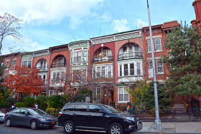
Two, three story red brick row houses
93 & 95 Milton Street
Two, three story red brick row houses
97 & 99 Milton Street
Two, three story red brick row houses
101 & 103 Milton Street
Two, three story red brick row houses
105 & 107 Milton Street
Two, three story red brick row houses
109 Milton Street
93-109 Milton Street:
The buildings in the above photos were designed and built by James R. Sparrow in 1873-1874. The buildings were designed in the then popular Renaissance Revival Style.[2] They adhere to the design principal of unity by maintaining a uniform height, fenestration and design style with matching details. Each façade was once painted in its own color to discern its individual identity.[1] According to the Landmarks Preservation Commission Report, the houses were likely built as two-family residences.  Most of the homes were sold to craftsmen that worked in the local trades. However, the buildings at 105-109 Milton Street were kept by the Sparrow Family as an investment. Most of the cast iron fences, as well as the stoop balustrades are original.[2]


One, three story red brick row house
111 Milton Street
111 Milton Street:
No. 111 is a neo-Grec style residence built circa 1881-82 by Thomas C. Smith.[2] Smith lived at the small mansion at 138 Milton Street. The Smith home is now the Greenpoint Reformed Church. Smith was the primary developer of Milton Street and designed the majority of the homes that still line the block.[3] I have more on Smith and his former home in an earlier post on the Greenpoint Reformed Church.
One two story row house with bay windows
115 Milton Street
115 Milton Street:
This two-story brick building is a Neo-Classical row house built by Dr. Charles A. Walters ca. 1894. The property was developed as an investment by Walters who lived next door at No. 111.[2]


One, three story red brick row house
117 Milton Street
117 Milton Street:
Thomas C. Smith built the Italianate style house pictured above. The house is a brick structure built atop a rusticated brownstone basement. The house has retained its original stoop balustrade and garden railing, as well as its window guards at the basement.[2]


Two story red brick duplex - row house
119 & 121 Milton Street
Two story red brick duplex - row house
123 & 125 Milton Street
119-125 Milton Street:
The houses are a row of four brick neo-Grec style residences built in 1876 by Thomas C. Smith. They are in two pairs designed to appear like two larger homes.[2]  Unfortunately, the façade of the house at 125 Milton Street has been disfigured and no longer resembles its original historic design. I am not sure why the facade was changed but it now looks like a bad repair job on a damaged building, leaving little historic value. Also, the cornice that spans 123 and 125 has been painted a different color for each address which looks like a mistake.


Two row houses
127 & 129 Milton Street
127 & 129 Milton Street:
Built circa 1876, these homes were also designed and constructed by Thomas C Smith. Due to “renovations” No. 127 no longer has its 19th century character. In the photo it is hiding behind the evergreen shrub but don't worry, you're not missing much. As a reference to what it would have looked like, No. 129 has remained largely unaltered, retaining its Italianate style.[2]


Red brick duplex row house with french style mansard roof
131 & 133 Milton Street
131 & 133 Milton Street:
The next pair of houses adds to the Smith collection of Milton Street structures. Differing from the last two, these were designed in the French influenced Second Empire style. Although No. 131 has been modified, both buildings retain their mansard roof and original iron work.[2]


Two red brick row houses
135 & 137 Milton Street
135 & 137 Milton Street:
More Smith homes… The houses were built in 1878 in the neo-Grec style.  The buildings had a two story bay that rose from the basement to the second floor at the side of each entrance which have since been removed. At No. 135 there is a picture window where the bay used to be and 137’s bay location has been covered with aluminum siding.[2]


Row of several similar red brick row houses with loggias
139-151 Milton Street
139-151 Milton Street:
This brings me to my favorite of all of Thomas C. Smith’s houses. This row of Queen Ann style residential structures maintains a unique identity on the street due to its small arched and recessed loggias.[1][2] The homes are unified by the loggias, as well as the types of brick used, lintels and galvanized-iron roof cornices.[2] If I could buy any building on the block it would be one of this group.


Red brick gothic revival style Lutheran Church
St. Johns Evangelical Lutheran Church
153-157 Milton Street:
St. Johns Evangelical Lutheran Church


Large neoclassical low rise apartment building constructed of red brick on a limestone first floor
159, 161 & 163 Milton Street
159, 161 & 163 Milton Street:
This building split between three addresses/entrances is a neoclassical structure constructed between 1904 and 1909.[2] The building is constructed of red brick on a first floor built of limestone.


References:
  1. White, Norval, Willensky, Elliot, and Leadon, Fran AIA Guide to New York. Oxford University Press, 2010.
  2. NYC Landmarks Preservation Commission Designation Report 14 September, 1982
  3. Spellen, Suzanne "Building of the Day: 138 Milton Street" Brownstoner.com 5 October, 2015

Saturday, December 19, 2015

Lundy's - Lundy Brothers Restaurant

Black and white postcard of Lundy Brothers Restaurant in 1950
Lundy's Historic Postcard ca. 1950 (image source: BrooklynPix)
Photo of Lundy's main facade from across the street, similar view to historic postcard
Lundy's Today
Neighborhood: Sheepshead Bay
Address: 1901 - 1929 Emmons Avenue

Before I get into the history of Lundy’s I should mention that the historic postcard above was purchased from Brooklyn Pix, operated by Brian Merlis. Should you want a thorough history of Brooklyn Neighborhoods I recommend checking out the series of Brooklyn Books he has co-authored with Riccardo Gomes. Their current book is Brooklyn’s Greenpoint and can be purchased at Word Bookstore in Greenpoint or online.

To see what Lundy's looked like while it sat abandoned visit Sheepsheadbites.com


Perspective photo of side of Lundy's along sidewalk
Lundy's
Restaurant
According to the Village Voice, Lundy’s Restaurant was “the city’s most humongous – and one of the best – seafood restaurants”. The restaurant began as a clam bar but evolved over time to become the largest dining establishment in the country during its peak, employing a staff of 385 people and serving as many as 5,000 meals a day.[1][3] Although the restaurant’s original incarnation opened in 1907 the building that is synonymous with the business was constructed in 1934. The establishment closed in 1981, reopened in 1995 utilizing half its original space and closed again in 2007.[1][2] Today, the building houses an upscale end food market.


Lundy' main facade from across the street
Lundy's
Architecture
The 1934 Lundy Brothers building was designed by architects Bloch & Hesse in Spanish Mission style for restaurateur Fredrick William Irving Lundy (1895-1977).[2][3] Bloch & Hesse architects specialized in restaurant design.[3] The structure’s style was described by the AIA Guide to New York City as strangely appropriate.[2] Upon viewing the building in person, it does somehow feel appropriately designed regardless of its seeming lack of context with the rest of the neighborhood. The Mission Style is more closely associated with California and the Southwest and is rarely seen in the New York metro area. The building encompasses an entire block and features “sand-colored stuccoed walls, low sloping red mission tile roofs, arched entrances, arcuated corbel tables, decorative iron work and leaded glass windows”. Lundy’s is thought to be the last remaining New York City restaurant building associated with the Mission Style.[3]


Panoramic view of Lundy's shot from directly across the street in the middle of the block
Lundy's Panorama

References:
  1. Sietsema, Robert "Five Dead and Gone Classic Brooklyn Restaurants" VillageVoice.com 31 March, 2011
  2. White, Norval, Willensky, Elliot, and Leadon, Fran AIA Guide to New York. Oxford University Press, 2010
  3. Harris, Gale F.W.I.L. "Lundy Brothers Restaurant Building" New York City Landmarks Preservation Commission Report 3 March 1992

Monday, December 14, 2015

Greenpoint Reformed Church

Greenpoint Reformed Church from Milton Street
Greenpoint Reformed Church
Neighborhood: Greenpoint
Address: 138 Milton Street

The Greenpoint Reformed Church is an odd one. Among the many churches still in operation in Greenpoint, it is not a Romanesque or Gothic Revival structure built on a grand scale; it is a humble mid 19th century mansion. That is not to say it’s not a beautiful building. If it were still being utilized as a residence here in North Brooklyn it would be a symbol of wealth. So, how did the church begin and how did it end up in a house?

The Church
The church began in 1848 as the Reformed Dutch Church of Green Point in a building located on the north side of Java Street near Franklin Avenue. The building was a gift of Magdalena Meserole. The expanding congregation eventually required a larger house of worship, at which point they commissioned architect William Ditmars to design a new structure on Kent Street. Built in 1870, the building remains to this day; however, the Reformed Dutch Church of Greenpoint congregation moved to the Thomas C. Smith mansion on Milton Street in 1944 where it remains under a slightly different name.[1] The church purchased the building from the YMCA, the organization that owned it after the Smith Family.[2] Once the church moved it was renamed to Greenpoint Reformed Church.[1] 

The House
The mansion that currently houses the church was the residence of Thomas C. Smith, a prominent Greenpoint resident, successful businessman and builder.[2] The Italianate Greek Revival style house was built in 1867.[3] At that time, architecture did not exist as the organized profession we know today. So, as a builder, Smith designed and constructed his house. He also built many of the other homes on Milton Street.[3][4] The house’s architectural characteristics are described in a section of the Landmarks Preservation Commission Reprt:


Built of brick, No. 136-138 is a freestanding, two story house, which is three bays wide. The full-height central bay projects, creating a pavilion. The entrance is protected by a portico with two smooth Tuscan columns carrying a modillioned pediment with raking cornice. Pilasters echo the columns where the pediment meets the façade. Above the entrance is a double window enframed by a simple sill and pilasters carrying a bracketed lintel. Projecting double window bays with architrave moldings and modillioned cornices flank the entrance at the ground floor. Above these are double windows with corbelled sills and cap-molded lintels. A cornice carried on neo-Grec brackets crowns the house.[4]

Black and White Union Porcelain Works Logo
Colorful, ornate antique vase made by Union Porcelain Works

Thomas Smith & Union Porcelain Works
In addition to being a builder, Thomas Smith was a producer of various porcelain wares. Smith had acquired a small porcelain doorknob manufacturing company to satisfy a debt. After the acquisition he studied the porcelain industry in England and France, then returned to retool the fledgling company to make it “the first hard porcelain factory in the United States”. He named the new enterprise Union Porcelain Works. The company manufactured restaurantware, industrial parts, tiles and other products. Union Porcelain Works closed in 1922 and the factory no longer exists but you can still see some of the company’s products at the Brooklyn Museum.[2]


Looking down Milton Street toward the Church of Saint Anthony of Padua
Milton Street After Filming the Knick
Portico of Greenpoint Reformed Church with Minetta Negro Infirmary Sign
Greenpoint Reformed Church as Minetta Negro Infirmary
On a side note, the church was converted into the Minetta Negro Infirmary for Steven Soderbergh's mini series The Knick featuring Clive Owen. The series is about the people of New York's Harlem based Knickerbocker Hospital around the turn of the last century.[5] I happened to come by to photograph the Church of Saint Anthony a couple of years ago, the day after the shoot and took some extra photos of the Greenpoint Reformed Church. The streets were still dusty from being covered with a sandy soil to create a dirt road and the church still featured the infirmary sign.

References:
  1. Brian Merlis & Riccardo Gomes Brooklyn's Historic Greenpoint Gomerl Publishing, NJ 2015
  2. Spellen, Suzanne "Building of the Day: 138 Milton Street" Brownstoner.com 5 October, 2015
  3. White, Norval, Willensky, Elliot, and Leadon, Fran AIA Guide to New York. Oxford University Press, 2010
  4. NYC Landmarks Preservation Commission Designation Report 14 September, 1982
  5. Jen G. "Greenpoint Filming The Knick: Horses on Milton St - Today" Greenpointers.com 23 October, 2013

Tuesday, November 17, 2015

Tobacco Warehouse at Brooklyn Bridge Park

Front, street side facade of the renovated tobacco warehouse with the Brooklyn Bridge in the background
Tobacco Warehouse - Saint Ann's Warehouse
Back, park side facade of the renovated tobacco warehouse with the Brooklyn Bridge in the background
Tobacco Warehouse - Saint Ann's Warehouse
Interior of the renovated tobacco warehouse for Saint Ann's Warehouse
Interior of Saint Ann's Warehouse
Neighborhood: Dumbo
Address: 45 Water Street

The former tobacco warehouse, (ca. 1855) sitting in the shadow of the Brooklyn Bridge, recently reopened as the theater space for Saint Ann’s Warehouse. The story of this building almost had a different ending. Although it was included in the Fulton Ferry Historic District in 1977, in 1999 the State Office of Parks, Recreation and Historic Preservation announced that the building would be demolished due to safety concerns after being damaged by a tropical storm.[1] I cannot find the reason for its survival but my guess is that the city, neighborhood or both protested its demolition. Like its proposed demolition, the building’s restoration was also uncertain. There were initially two competing theater groups interested in utilizing the space. After Saint Ann’s won the bid to occupy the old warehouse, neighborhood organizations sued to keep the building completely within the public domain. At one point it looked as though Saint Ann’s would not be moving in but eventually a comprise was struck and the building now houses the Theater.[2] A more detailed account of Saint Ann’s battle is well documented in Curbed’s archived blog posts if you’re interested (the related Curbed posts have since been removed). The theater is 25,000 square feet with a capacity for 300 to 700 people. In addition, the building hosts a multi-use artists' studio and an exterior courtyard (incomplete as of this post) that will be open to the public during park hours.[3]

References:
  1. Holt, Dennis "Old Tobacco Warehouse on B'klyn Waterfront, Relic of the 1850s, To Face Wrecker's Ball" Brooklyn Daily Eagle 23 September, 1999
  2. "Tobacco Warehouse" Curbed
  3. "Saint Ann's Warehouse at the Tobacco Warehouse" NYC The Official Guide

Saturday, November 7, 2015

Red Hook's Waterfront Museum Barge

Red historic barge with Leigh Valley and the number 79 painted in white on the side
Waterfront Museum Barge
Gangways leading to red historic barge with Leigh Valley and the number 79 painted in white on the side
Waterfront Museum Barge
Red Hook has many unusual and obscure places that help define the neighborhood’s character and make it a fascinating place to explore. One such semi-obscure point of interest is the Waterfront Museum barge near Fairway.


Adaptation of Moby Dick being performed inside the Waterfront Museum
Performance of Moby Dick Inside Barge
Red Hook’s Waterfront Museum is housed in a 101 year-old historic Leigh Valley railroad barge. The historic vessel is listed on the National Register of Historic Places.[1][2] The barge was originally used to ferry cargo like dates, nuts and olive oil through New York Harbor.[3] Before the barge was purchased by the museum’s president David Sharps in 1985, it had been run aground off New Jersey's Hudson River shoreline. After purchasing the vessel for a dollar, Sharps restored it for use as a cultural and educational space. Then, in 1986 he founded the Waterfront Museum.[1][4] The museum relocated to Red Hook ca. 1994.[5] The barge has hosted music performances, circus acts, art exhibits and theater productions among others.[1] In addition, the museum promotes the barge as a “floating classroom” to school groups for learning about geography, history, social studies and science.[4] On a recent Friday evening I went to see a theatrical adaptation of Moby Dick at the Waterfront Museum. The museum made excellent use of their space as a minimalist set and the actors did a great job bringing the story to life. David Sharps was once a performer himself. He began his career as a clown and juggler aboard Carnival Cruise Ships, so this sort of entertainment is familiar territory for him.[3]


Red historic barge with Leigh Valley and the number 79 painted in white on the side and little white sailboat tethered to barge
Waterfront Museum Barge
If you are in the area during the museum’s limited hours on Thursday and Saturday I recommend checking it out. Or, you could check out one of the performances at the barge. If you find yourself in Red Hook with some free time, I also highly recommend a walk along the waterfront. There are several interesting places to explore. I have visited and blogged about the Grain Elevator, Fairway’s abandoned Trolley and now the Barge Museum, however, there is still a lot more to see.

References:
  1. Karp, Daria “Red Hook Performance Barge-Museum Receives More Than $50,000 in Grants” Brooklyn Daily Eagle 1 May, 2003
  2. Curtis, Lisa J. “Save the Barge” The Brooklyn Papers 13, May 2002
  3. Kennedy, Randy “A Return to Its Maritime Roots” New York Times 26 July, 2005
  4. Museum History WaterfrontBargeMuseum.org
  5. The Waterfront Museum and Showboat Barge NewYorkMag.com 

Saturday, October 31, 2015

Greenpoint Shul - Congregation Ahavas Israel

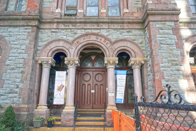
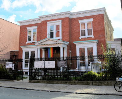
Temple Beth-El & Congregation Ahavas Israel Buildings
Greenpoint Shul - Congregation Ahavas Israel
Neighborhood: Greenpoint
Adress: 108 & 110 Noble Street

Shul History
The buildings occupied by the Ahavas Israel Jewish congregation in Greenpoint were once two separate Synagogues. The now defunct Temple Beth-El Synagogue was a reform congregation organized in 1886. They met in Germania Hall on Franklin Street prior to purchasing the structure on 108 Noble Street from the Church of the Reconciliation in 1887. The Church of the Reconciliation building was constructed ca. 1871.[1][2] Under the leadership of Rabbi M.J. Luebke their services were held in German and Hebrew. After the dismissal of Luebke in 1897, sermons were given in English.[1] Originally located in Keramos Hall on Manhattan Avenue, Congregation Ahavas Isreal partnered with the Congregation Shayrish Israel (Congregation of the Relic of Israel) and began construction on their new synagogue adjacent to the Temple Beth-El Israel in 1904.[1][2] As industries left Greenoint much of Temple Beth-El’s congregation went with them. With a shrinking congregation the Temple Beth-El disbanded.[3] Today, Ahavas Israel owns both buildings and is the last of five synagogues in Greenpoint.[1][3]
Stained glass windows of the two synagogues side by side
Temple Beth-El & Ahavas Israel Windows
Architecture
The building formerly occupied by Temple Beth-El has Gothic-Revival features on a townhouse like frame. Ahavas Israel had their building designed in the Romanesque Revival style. The difference in styles is most apparent in the fenestration of the two buildings. The Temple Beth-El building has lancet windows and an entrance with a pointed arch, typical features of its style. Ahawath Israel’s original house of worship features rounded Romanesque arches. It’s worth noting that the Beth-El building once had a square dome at the front of it.

Interior
Ahavas Israel’s original sanctuary is cream colored and surrounded by a wood-faced balcony. Overhead is a barrel vaulted ceiling with three skylights. Additional light is provided by a Victorian era chandelier with frosted glass.[3] Additional details regarding the building’s interior listed in the book “Sacred Havens of Brooklyn” are quoted below.
All eyes are drawn to the holy ark, guarded from above by golden lions of Judah that flank gilded tablets of the Ten Commandments. A wheel window above the ark is filled with the stained-glass Shield of David outlined in red against a turquoise sky. Colorful stenciling surrounds the window and ceiling, while a dark wood bema, the reading of the table for the Torah scrolls, has brass menorahs on each corner.
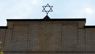
Star of David sitting on top of Ahavas Israel building's cornice

References:
  1. Brian Merlis & Riccardo Gomes Brooklyn's Historic Greenpoint Gomerl Publishing, NJ 2015
  2. "Our History" GreenpointShul.org
  3. Cook, Terri Sacred Havens of Brooklyn. Charleston South Carolina: The History Press, 2013

Thursday, October 22, 2015

Church of St. Luke and St. Matthew

Front of church
Church of St. Luke and St. Matthew
Decorative stone arch of the main entrance of church
Arch Over Main Entrance to Church
Chapel entrance featuring three stone arched openings in front of a decorative wood door
Chapel Entrance
Neighborhood: Clinton Hill
Adress: 520 Clinton Avenue

The Church
The Church of St. Luke and St. Matthew was not the first at this location. The original church located on this site was built in 1835 for the Trinity Church congregation. However, the congregation was unable to successfully grow and when it couldn’t meet its financial obligations, they lost the property in foreclosure. Their original square rubblestone structure was incorporated into the design of the existing church. The following church to utilize the site was St. Luke’s Protestant Episcopal Church, organized in 1841; the St Matthews congregation didn’t join the church until 1943. Additions to the original structure were added by the new church in 1853 and 1886. A fire destroyed much of the building in 1887. So in 1888-1891 St. Luke’s rebuilt the church resulting in the existing, grand ecclesiastical structure here today.[1] It was and still is the largest Episcopal Church in Brooklyn.[2]

Interior shot facing the apse from behind the pews showing the columns, pews and vaulted ceiling
Church of St. Luke and St. Matthew Interior
Rose window with stained glass
Rose Window
Lancet windows with Tiffany Stained Glass depicting the Magi's visit to baby Jesus
Tiffany Stained Glass Church Window
Showing Magi's Visit to the Infant Jesus
Image of ceiling over choir and apse showing stained glass windows of the apse and stained glass skylight
Ceiling Above Choir & Apse
Three images showing the organ, a typical hanging light and a gold colored decorative pulpit on a pedestal
Organ, Light & Pulpit
White reredo flanked by angels showing St. Peter, St. Paul and a crucifixion scene at rear of apse below the apse's stained glass windows
Church of St. Luke and St. Matthew Reredo
Architecture
Designed by John Welch, the church boasts a classically inspired façade modeled after the basilicas of Italy.[1][2] John Welch was a Brooklyn architect responsible for designing many churches. The AIA Guide to New York City refers to the church’s style as “Eclecticism gone berserk”.[3] Indeed, there are elements of several design motifs contained within the building; although, Romanesque Revival is the dominant architectural style. The façade features “greenish stone walls, Romanesque arches, and Ruskinian Gothic polychromy in three shades of brown”.[3]

The twenty eight foot diameter rose window over the entrance, one of the largest in Brooklyn, was donated by the children of the Sunday School in 1890.[1] Most of the windows in the nave were produced by Tiffany and installed in 1896-1897.[1][2] All but one of the sets of stained glass windows has a scriptural theme. Although, the north and south transepts were originally furnished with pews, they are now more open and house religious artifacts including an altar from the Church of St Michael on Adelphi Street. The pulpit was dedicated after the church was rebuilt in 1890. On opposite sides of the chancel is the organ, built by M. P. Mollar in 1916, and wood choir stalls.[1] The apse windows, alter and reredos are part of the 1853 construction.[2]

For a more detailed history of the church visit it during Open House New York. They participate in OHNY every year.

More Photos

References:
  1. “The Church of St. Luke and St. Matthew, A Guide to the Building” Church Brochure for OHNY
  2. Cook, Terri Sacred Havens of Brooklyn. Charleston South Carolina: The History Press, 2013
  3. White, Norval, Willensky, Elliot, and Leadon, Fran AIA Guide to New York. Oxford University Press, 2010

Saturday, October 17, 2015

Fort Tilden - Queens

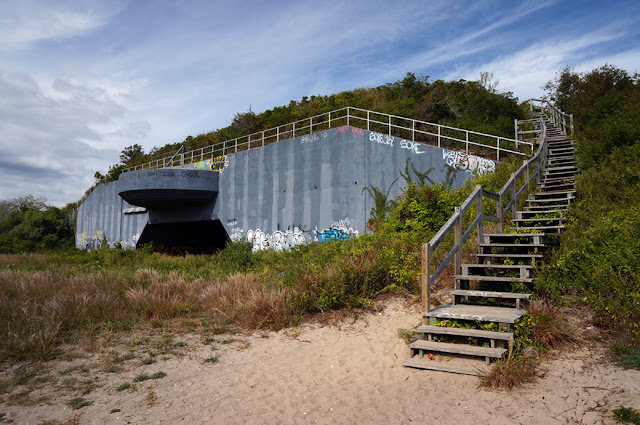
Photo of Battery Harris East showing steps to observation platform above in the foreground
Battery Harris East
I’m stepping out of Brooklyn for this post on Fort Tilden. Just across Jamaica Bay from Marine Park’s Dead Horse Bay is Fort Tilden, a popular spot for Brooklynites and Queens residents alike.

Intro
Located on the southwest end of the Rockaway Peninsula, Fort Tilden was an army base of 309 acres strategically located to defend New York Harbor. The base was built in 1917 as part of an emergency military buildup during WWI. The base began with smaller 12” gun batteries to defend against maritime threats but evolved over time to address new advances in military technology, as well as new types of warfare.[1] Although covered with dunes and vegetation today, most of the base was once  an open landscape.[2] In 1974 military operations ceased and the base was turned over to the National Park’s Service for incorporation into the Gateway National Recreation Area. After being decomissioned nature was allowed to return the base's landscape to the natural state it's in today.[1][2]


Large 16" anti-ship artillery gun on beach of Fort Tilden
Fort Tilden 16" Gun Emplacement
Looking down barrel of large 16" anti-ship artillery gun on beach of Fort Tilden
View of Crew and Rails for Munition Supply from Barrel of 16" Gun
(Photo Source: History of Fort Tilden at www.oocities.org)
Nike Hercules Missile pointed up on launching device at Fort Tilden
Nike Hercules Missile at Fort Tilden
(Photo Source: Techbastard.com)
Looking out from mouth of Battery Harris East bunker
Looking Out from Under Battery Harris East Bunker
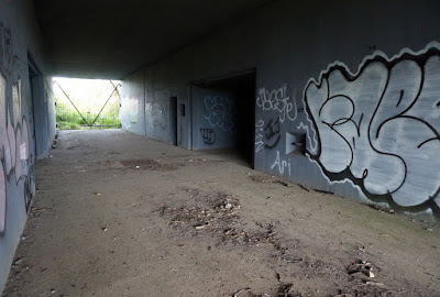
Looking into the interior corridor of Battery Harris East with entrances to rooms on either side of corridor
Looking Into the Battery Harris East Bunker
Machine gun pill box in the vegetated dune behind Fort Tilden Beach
Pill Box / Machine Gun Nest
Defenses and Fortifications
The fortifications and armament constructed during WWI were part of the Taft system of defense. Secretary of war William Taft outfitted U.S. defense fortifications with electric lights, motorized ammunition hoists, searchlights, telephone communications and observation posts for accurate targeting of enemy ships. After WWI anti-aircraft guns and camouflage were added to address the new threat from aerial attack. In the mid-1930s, prior to the Second World War, the depression era WPA constructed many additional buildings on the base. During WWII, larger, M1919MII 16" gun batteries were added and existing guns were fortified in concrete bunkers known as casemates, with additional protection and camouflage provided by a cover of sand and vegetation. From above the batteries are hidden within the dunes. In 1954-1955, during the Cold War, Fort Tilden’s defense capabilities were enhanced with additional anti-aircraft guns and Nike surface to air missiles.[3]  
Fort Tilden Building
Fort Tilden Magazine Building
Remaining Buildings
Since the base was decommissioned much of its infrastructure, including large gun mounts on the beach, has been covered by sand dunes and maritime vegetation. Many of the remaining buildings have been unmaintained, vandalized and damaged by storms including Hurricane Sandy. The most impressive remaining structures include 4 large artillery bunkers known as Battery Harris East and Battery Harris West. One of the bunkers has an observation platform with public access. In addition to the bunkers there are pill boxes (machine gun nests) in the dunes behind the shoreline, a hanger, magazine buildings (for ammunition storage) and a generator building among others.[5] 

The Park
If you visit Fort Tilden today, there are many types of park programs and facilities for you to take advantage of. The Rockaway Artist Alliance and the Rockaway Theatre Company offer cultural programming. “Tours and ranger-led programs highlight many great spots to see wildlife in the maritime forest”. The observation deck on top of one of the bunkers can be used for taking in panoramic views and bird watching.[4] For active recreation, the shoreline offers typical beach activities and there are athletic fields for soccer and baseball at the east end of the park.

Additional Photos

View of Rockaway and Gil Hodges Memorial Bridge from observation platform
View from Observation Platform on top of Battery Harris East

References:
  1. "A Detailed History of Fort Tilden" NationalParksService.gov
  2. Selvek, Christina & Auwaerter, John Cultural Landscape Report for Fort Tilden Olmstead Center for Landscape Preservation - National Park Service, Boston Massachusetts, 2005
  3. “Nike Missile Site NY-49 Fort Tilden New York” TechBastard.com
  4. “Fort Tilden” NewYorkHarborParks.com
  5. "The History of Fort Tilden" www.oocities.org