Saturday, August 29, 2015

Greenpoint Library - Carnegie Library

Color postcard of original Greenpoint Carnegie Library
Greenpoint Carnegie Library - Historic Postcard
Greenpoint Library from the opposite corner
Existing Greenpoint Library
Greenpoint Library Entrance
Mural on side of Greenpoint Library
Greenpoint Library Mural
The current Greenpoint Library was not always as it is today. Someone I know referred to the building as a bomb shelter, and I can understand why. The building has a low profile and maintains an emphasis on the horizontal plane with its windows and roofline giving it a squat (and sturdy) appearance. In addition, the choice of materials seem a little drab. That said, I could forgive the library’s dated aesthetic if I didn’t know about the building that once housed the same institution. 

On the corner at 107 Norman Avenue and Leonard Street, where the existing Greenpoint Library sits used to be a brick and limestone Classical Revival style Carnegie Library.[1] Libraries were one of steel magnet Andrew Carnegie’s favorite philanthropic ventures. Any municipality that provided a site and would fund, stock and support a new library could receive funding for design and construction of the building from Carnegie.[2] Designed by architect R.L. Daus, the Carnegie Library received praise from the Greenpoint Star for its “tasteful simplicity”.[1][2] The building was constructed in 1906 at a cost of 75 thousand dollars and was Brooklyn’s 8th Carnegie Library. Unfortunately, the structural integrity of the building’s foundation was compromised and since it was "too expensive to repair", in 1970 the library was demolished.[2] The existing library was built in 1973; the mural by artist Leslie A. Wood gracing the structure’s walls with some much needed visual appeal was painted in 2013.[1]

Sources:
  1. Greenpoint Library BrooklynLibrary.org
  2. Brian Merlis & Riccardo Gomes Brooklyn's Historic Greenpoint Gomerl Publishing NJ 2015

Thursday, August 27, 2015

Red Hook Grain Elevator - New York State Barge Canal Grain Elevator

Red Hook Grain Elevator Historic Aerial Photo
Red Hook Grain Elevator Today
Red Hook Grain Elevator - West Side
Red Hook Grain Elevator - North Side
Red Hook Grain Elevator - South Side
Taking just 16 short months to build, the grain terminal was constructed in 1922 at a cost of 2.5 million dollars. The elevator is 70 feet wide and 429 feet long. Initially the structure also contained movable booms that transported the grain as it was rinsed, dried, cooled and stored. A 1,221 foot-long conveyor would deliver grain directly to freighters docked adjacent to the elevator.[1]

The grain elevator was built to serve the New York State Barge Canal System, a series of waterways conceived at the turn of the last century, and meant to replace the Erie Canal. The system connected Lakes Erie and Champlain to the Hudson River and the port of New York. By 1918 the Barge Canal system was being utilized at a mere 10 percent of capacity. It was theorized that part of the reason for lower demand of the waterway was that New York lacked the storage capacity for large volumes of grain. Grain was predominantly moved by barge and rail and while grain elevators existed in New York, the railroad companies owned them and weren’t interested in sharing the storage space. In theory, larger quantities of grain should have been reaching the Port of New York from the Great Lakes area. So, in an effort to increase shipping along the Barge Canal, the State commissioned the hulking grain elevator at the foot of Columbia Street.[1]


Red Hook Grain Elevator from Red Hook Park
Red Hook Grain Elevator Dance Party
Red Hook Grain Terminal
Most grain elevators in Brooklyn were built in the late 19th century and were half the size of the Red Hook facility. Oversized and built at a time when more shipping options existed, the Red Hook Grain Elevator was obsolete from its inception.[2] Moreover, storage capacity for grain was not the only problem facing the Red Hook terminal. Other problems included significantly cheaper costs for processing grain at other ports and the opening of the Saint Lawrence Seaway in 1959 reduced an already disappointing volume of grain freight. The facility was never profitable and only used for approximately 40 years. Closing in 1965, “Red Hook’s magnificent mistake” looms over Red Hook Park like a ghost from the past. The loading pier and conveyor structure were demolished in 1987.[1] Today the grain elevator is used as an occasional event space, and a playground for urban explorers and photographers on the ruin porn beat. In August of 2002 choreographer Joanna Haigood and the Zacho Dance Theater staged a large aerial performance with dancers scaling the silo walls, in 2013 David Bowie filmed his single for “Valentine’s Day” inside the terminal (see video below) and while I was shooting photos for this post there was a large dance party underway (see photo above).[2][3]

For those who are interested, it is easy to access the site from Red Hook Park. However, be warned, according to reports people are caught and fined often. I would love to access the elevator for some interior shots but for professional reasons, I cannot afford to be caught trespassing.


Sources:
  1. Gray, Christopher “Red Hook’s 1922 Magnificent Mistake” New York Times 13 May, 1990
  2. "Inside Red Hook's Massive, Eerie Grain Elevator" Gothamist 17 February, 2014
  3. Hays, Elizabeth "Harvest of Dance at Grain Elevator" Daily News 21, August 2002

Saturday, August 22, 2015

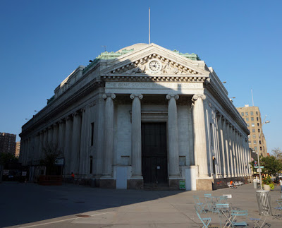
Dime Savings Bank - Downtown Brooklyn

Facing the entrance of the Dime Savings Bank in Downtown Brooklyn
Dime Savings Bank - Downtown Brooklyn
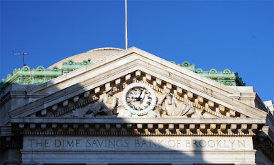
Closeup of pediment over entrance of Dime Savings Bank in Downtown Brooklyn
Dime Savings Bank Pediment


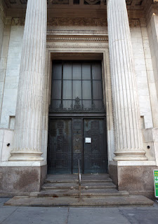
Closeup of entrance of Dime Savings Bank in Downtown Brooklyn
Dime Savings Bank Entrance
Closeup of bronze relief between doors of Dime Savings Bank in Downtown Brooklyn
Relief of Mercury Between Doors
Looking down the colonnade on south wall of Dime Savings Bank in Downtown Brooklyn
South Side of Dime Savings Bank
Chartered in April 1859, the Dime Savings Bank opened in Brooklyn in June of the same year.[1] The former Downtown Brooklyn branch of the Dime Savings Bank at 9 Dekalb Avenue is a Roman Revival style structure built 1906-08 on the northeast corner of Dekalb Avenue and Fleet Street.[1] The original building was designed by Mowbray  & Uffinger; it was later enlarged by Halsey, McCormack & Helmer in 1931-1932.[2][3] Both firms were already known for designing impressive banks prior to being commissioned to design the Dime Savings Bank. Mobray & Uffinger had also designed the People's Trust Company on Montague Street and Halsey, McCormack & Helmer were well known for designing the Williamsburg Savings Bank Tower.[3] Numerous architectural elements within the building are used as symbolic references. Mercury, the Roman God of commerce, is the prominently featured symbol of the Dime Savings Bank and is included in the building in stone, as well as bronze reliefs. Along with brick, the building was clad in Pentelic marble quarried from the same source the ancient Greeks used to acquire stone for the construction of their temples, including the Pantheon.[1] Security and stability are communicated through the overall classically inspired architectural composition itself. The elements within the composition are best described in An Architectural Guide to Brooklyn:
The entrance to the bank is splendid, holding the space with all the authority and skill that architecture can muster. It is a projecting tetrastyle Ionic portico from which the east and west side of the building flare to the north. The portico is crowned by one of the best triangular pediments in Brooklyn, filled, as such pediments should be, with sculpture semi-reclining figures flank a beautiful clock. Colonnades of fully modeled Ionic columns are recessed within the east and west walls of the building. The top floor, with anthemion cresting, forms a platform for a fine, broad saucer dome.
Various financial institutions occupied the Dime Savings Bank building prior to it being vacated and put up for sale by its most recent owner, Chase Bank. JDS Development and the Chetrit Group recently purchased the building, as well as, 300,000 square feet of included development rights on the block from Chase. To date, the pair of development corporations has amassed a total 600,000 square feet of development rights for the site. So, in theory, they could erect a building as tall as the Empire State Building and include the landmarked bank as part of the future residential site.[4] 

Sources:
  1. NYC Landmarks Preservation Commission Chester Court Historic District Designation Report 19 July, 1994
  2. White, Norval, Willensky, Elliot, and Leadon, Fran AIA Guide to New York. Oxford University Press, 2010.
  3. Morrone, Francis An Architectural Guidebook to Brooklyn. Gibbs Smith, Publisher, 2001.
  4. "1,000 FT Tower is Probably Coming to Downtown Brooklyn" Curbed 5, August, 2015

Saturday, August 15, 2015

Chester Court - Flatbush

Houses on South Side of Chester Court
Chester Court - South Side
Houses on North Side of Chester Court
Chester Court - North Side
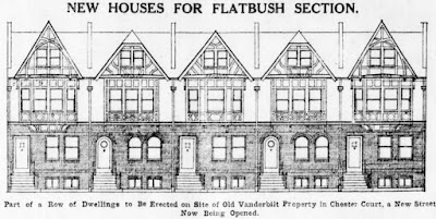
Architectural elevation of typical Chester Court houses
Chester Court - Architectural Elevation
(Brooklyn Daily Eagle 28 October, 1911)
Photographic elevation of existing Chester Court houses
Chester Court - Photo Elevation
Built in 1911, Chester Court is a double row of Tudor Revival style homes that comprise most of the small block they reside on, extending from 16 to 32 Chester Court. The quant dwellings were designed and built by prominent Brooklyn architect and developer Peter J. Collins.[1] The style of the homes was based on the design vernacular of 16th and 17th century houses Mr. Collins observed in Chester England, hence the street name “Chester Court”.[1][2] The street traversed what was once part of the Vanderbilt family homestead to the right of where their house once stood.[2][3] The property had been in the Vanderbilt family since 1661.[2] Although the Tudor style had been used for single family detached houses for some time, Chester Court is thought to be among the first developments in the city to use the style for row-houses.[1] Staying true to the style, each home was built of timber, stucco and brick laid in a Flemish bond and featured an “attractive front court”.[1][3]


Looking west down Chester Court from Flatbush Avenue
Chester Court - Facing West from Flatbush Avenue
Street View of Chester Court Wall at end of street
Chester Court Wall
(Google Street View)
The neighborhood in which Chester Court resides was predominantly rural until the late 1800s when suburban development began happening on a larger scale. The new development boom followed transportation improvements that made the area more accessible for commuters, as well as the construction of Prospect Park. One of those transportation improvements was the Brooklyn, Flatbush & Coney Island Railroad, now the Brighton Q and B subway line, which is on the other side of the original brick wall on the west end of Chester Court.[1]

Sources:

  1. Caratzas, Michael NYC Landmarks Preservation Commission Chester Court Historic District Designation Report 16 December, 2014
  2. “Old Vanderbilt Homestead Which is to be Dismantled” Brooklyn Daily Eagle 28 September 1911
  3. NY House Histories "Saving Flatbush History - Chester Court" 20 November, 2014